Mayor and Council to Discuss Affordable Housing, Environment, and a $plash Pad
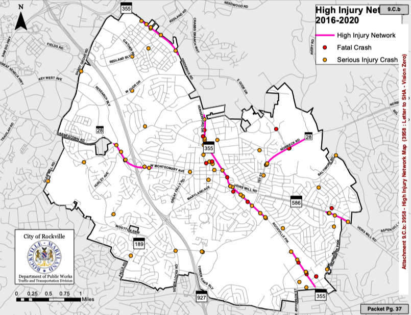
At its Monday, December 6, 2021 meeting, the Rockville Mayor and Council will discuss moderately priced housing (adding 30- to 99-year rent control periods); abandoning a “paper” street adjacent to 205 Mount Vernon Place in Hungerford; and allowing 350 apartments instead of offices in Fallsgrove. On the Consent Calendar (items approved without discussion) are a $322,364 splash pad for Maryvale Park (requested by the East Rockville Civic Association); a CDBG grant application to Montgomery County ($263,000 for the maintenance and repair of low-income housing); and letters to SHA (regarding traffic and pedestrian safety; most dangerous is the Rockville Pike) and WMATA (reduced service, access, and safety—can we all agree that WMATA has among the worst planners and project managers of any agency in the region?). The Mayor and Council will also receive reports from the Environment Commission and on an Employee Compensation and Classification Study (current salaries are generally competitive).
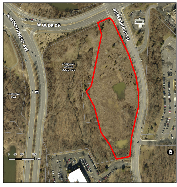
Continue reading →Mayor and Council to discuss 350 Multifamily Unit Development in Fallsgrove
At its Monday, November 1, 2021 meeting, the Rockville Mayor and Council will discuss board and commission appointments; water and sewer rates; and construction of 350 multifamily units in Fallsgrove. On the Consent Calendar (items approved without discussion) are no items. The Mayor and Council will also receive reports on cultural arts; bikeway and pedestrian master plans; and the 2022 state legislative priorities.
Key West Center Fallsgrove LLC is requesting permission to building up to 350 multifamily units on an undeveloped property at 1800 Research Boulevard. It is currently zoned for research-and-development offices, but they are requesting a change to residential use, exceed the number of apartments allowed in Fallsgrove, and exceed the building height restrictions. In addition, they are asking to retain the ability to construct an office, if market conditions change (“having their cake and icing, too”). The property is within the Richard Montgomery Cluster Area. According to a 2019 traffic study, the project will “not substantially alter or change the projected and approved vehicular traffic flow movements in and around the subject site.” The Planning Commission had twice approved projects for eight-story office buildings, but nothing was built.
More details in the 226-page agenda packet available at https://www.rockvillemd.gov/AgendaCenter/ViewFile/Agenda/_11012021-6394.
Is Rockville Walkable? Depends Where You Are.

Walk Score map of Rockville
“Walkability” is an increasingly popular measure of a community’s quality of life. By enhancing the convenience and ease of walking, it reduces traffic, improves health, increases community involvement, and puts more eyes on the street for safety. So how does Rockville rate? Walk Score calculates walkability on a block-by-block basis, generating color-coded maps. In the map of Rockville, green indicates the areas that are most walkable (such as downtown) and red the least walkable (such as Horizon Hill west of 270). Around town, they’ve calculated how the following locations fared on a scale of 1-100:
- 85 Very walkable: Maryland Avenue and South Adams (West End)
- 75 Very walkable: Baltimore Road and Grandin (East Rockville)
- 66 Somewhat walkable: Twinbrook Parkway and Viers Mill (Twinbrook)
- 65 Somewhat walkable: Fallsgrove Boulevard and Fallsgrove Road (Fallsgrove)
- 65 Somewhat walkable: Redland Boulevard and Pleasant (King Farm)
- 63 Somewhat walkable: West Montgomery and Laird (West End)
- 48 Car dependent: College Parkway and Princeton (College Gardens)
- 35 Car dependent: Falls Road and Kersey (Horizon Hill)
I’m sure this will generate controversy and prompt comparisons between neighborhoods (what!? Twinbrook rated the same as Fallsgrove and King Farm? Not possible!) but I’d really like to encourage a discussion about making our community more bike and pedestrian (and sometimes car) friendlier.
What makes a neighborhood walkable? According to Walk Score, the more of the following characteristics it has, the better:
- A center: Walkable neighborhoods have a center, whether it’s a main street or a public space.
- People: Enough people for businesses to flourish and for public transit to run frequently.
- Mixed income, mixed use: Affordable housing located near businesses.
- Parks and public space: Plenty of public places to gather and play.
- Pedestrian design: Buildings are close to the street, parking lots are relegated to the back.
- Schools and workplaces: Close enough that most residents can walk from their homes.
- Complete streets: Streets designed for bicyclists, pedestrians, and transit.
The City of Rockville recently received federal funds to develop “complete streets” near the Twinbrook and Rockville Metro stations, so scores for those locations (and pedestrians using those locations) should improve as a result. Any suggestions to make your neighborhood more walkable? Should walkability be a goal for Rockville?
