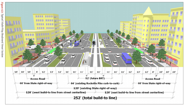
Rockville Planning Commission’s proposal for a 252′-wide ROW for the Rockville Pike. It includes eight lanes for cars, two lanes for Bus Rapid Transit, four lanes for bikes, and two sidewalks for pedestrians along with landscaped medians and left-turn lanes.
On Monday, May 9, the Rockville Mayor and Council will continue its worksession on “Rockville’s Pike Neighborhood Plan.” Along with building heights and pedestrian crossings, traffic congestion is a major controversy and the conversation has become terribly confusing: widening or narrowing the road, keeping or eliminating the access roads, extending adjacent roads, increasing Metro service, and incorporating bus rapid transit (BRT). Some of these solutions are beyond the control of the City (such as Metro service), some benefit one group versus another (such as businesses or nearby residents), and others are so expensive or far in the future that their feasibility is unclear (such as the BRT). What’s become incredibly confusing are all the numbers that are tossed around (what is the width of the Pike?) as well as a clear understanding of the benefits and disadvantages for the various alternatives.
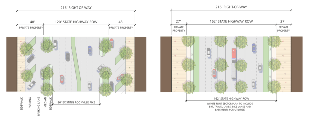
B. F. Saul’s “Reimagine Twinbrook” proposal for a 216′-wide ROW for the Rockville Pike (eight lanes for cars without BRT on left; six lanes for cars with BRT on right).
For example, the B. F. Saul Company owns several parcels on the Pike and is using its “Reimagine Twinbrook” campaign to encourage a narrower road width than proposed. Rather than 252 feet, they are seeking 216 feet to ensure, “plenty of right-of-way for traffic lanes, the future BRT, bike lanes, and large sidewalks, while providing more open space for the community. It also relieves taxpayers from the burden of buying land, constructing and maintaining unnecessary access lanes.” Their maps show a 216′ wide right-of-way (ROW), a 120′ wide State Highway ROW, and an 86′ wide Existing Rockville Pike. So how wide is the Pike?

Local access lane configuration with one-way traffic, parking, two-way bike path, and wider sidewalks as proposed by the 252′-wide ROW.
The current Rockville Pike Plan (adopted in 1989) has a 270′ wide ROW (measured from building face to building face). That’s what has been followed up and down the Pike for new construction since 1989. The best place to see it in action is between the newest buildings near Halpine Road (the REI store on the west to the Safeway/Galvan apartments on the east). The Planning Commission recommended a narrower ROW width of 252′ (measured from building face to building face) by reworking the access roads. Instead of the current two-way configuration, they propose one-way local access roads with parking, adding a two-way bike lane, and widening and relocating the sidewalk along the front of the building and away traffic. Although the Planning Commission’s proposal is 18′ narrower than the current standard (for comparison, roadway widths are 10-12′ wide), it resolves the current mishmash of access roads, as well as improves traffic for all users of the Pike, from drivers to pedestrians, bicyclists to bus-riders. Pedestrians encounter several medians where they can safely wait while crossing the Pike—they’re not crossing 252′ at one time unprotected. At most, pedestrians will cross three lanes of traffic (34′) before encountering a wide median, which should accommodate the slowest walkers.
At the request of the Mayor and Council, staff recently prepared a 216′-wide alternative (measured from building face to building face) which maintains three traffic lanes in each direction, adds BRT and bike lanes, and eliminates the access roads—which is pretty much the same as the B. F. Saul proposal (when you try to incorporate a lot of items in the same road, there’s only so much you can do).

David Greene’s map shows the current traffic quality at intersections on or near Rockville Pike.
Twinbrook resident David Greene is concerned that the 216′-wide alternative will worsen an already bad traffic situation. He points out that, “the proposed 252-foot right-of-way is actually narrower than the current 270-foot right-of-way, and closing the existing access lanes [under the 216′-wide alternative] will increase traffic congestion according to city staff. Many intersections are already failing, and the Mayor and Council appear likely to change the definition of ‘failing’ by raising the standards or by calculating them differently.” He prepared a map showing some of the intersections that are currently failing (F) or almost failing (E). “If you drive on Twinbrook Parkway during evening rush hour, then you already know about these problems.”
My conclusion is that the Planning Commission’s proposal of a 252′-wide ROW is the right way to go. It thoughtfully accommodates many existing demands for transportation as well as what will be likely needed in the next 20-30 years. We’re not thinking bigger, but smarter. Narrowing down even further to a 216′ ROW eliminates the access roads (that’s two lanes for automobiles), which seems to be exactly the opposite of what needs to be done to address the current traffic woes. If you’re not sure, count the number of traffic lanes in each scenario. Secondly, B. F. Saul’s 216′-wide campaign is not a philanthropic endeavor. By narrowing the width of the Pike, they increase the size of their land. The 252′-wide proposal is already increasing their property values, do I really want to give them more in exchange for suffering with even worse traffic for decades to come?
Costs? Yes, it will cost millions to implement, but that’s true no matter which option is chosen. Secondly, it’s a plan that’s implemented over many years with contributions from the city, county, state, and developers (still to be determined, but that’s typical—no one commits unless there’s a plan). Finally, so much is still undecided (will BRT be implemented? will utilities be placed underground? will the state be willing to acquire the additional ROW?) that the cost estimates being tossed around are unreliable. What’s being proposed at a 252′ wide ROW is what you’d expect for a very busy highway next to a suburban neighborhood (sorry, there’s no way you can convince me that the Pike is a country road). This isn’t an outrageous vision with a price tag to match. We’re going to have traffic congestion, so let’s encourage it in commercial districts such as the Rockville Pike, not in residential areas. If someone claims that taxes will increase if this Plan is adopted, ask them “how much?” A dollar? Ten dollars? One hundred dollars? Then ask if the cheaper alternative is a better alternative. I’d happily see my taxes increase that much each year if it’ll make Rockville Pike function and look better than it does now. At least I’ll be able to see where my taxes dollars are going (and if you care about taxes, you should know that not one person has complained to the County Council about their recent effort to increase property taxes, which accounts for the bulk of our local tax payments).
Here’s what I know for sure: the current 1989 plan is woefully out of date and the Pike is a mess. We need to have a plan to get it fixed and the Planning Commission’s 252′-wide recommendation looks like the right one, not B. F. Saul’s 216′-wide version.

Max,
What no one seems to ask is how all this increased pass-through commuter traffic will benefit the citizens of Rockville? Many have questioned this but there have been few answers. The potential for every neighborhood being negatively impacted by all the new traffic and congestion is great. And for what benefit?
The County and state just want to push more traffic through Rockville. I was around in the 1980’s when the county and state sold the expansion of Interestate 270 through Rockville as a way to reduce traffic on Route 355; what a ruse that was!
How about our consumer friendly reptile that most residents like about the Pike?. Roger Lewis, Architect and Urban Specialist, told the Planning Commission that will be gone, replaced by new commercial development. So what does the Pike become? It will simply be another highway to move massive traffic through Rockville. Is this what we want?
The devil you know is better than the devil you don’t!
Jim
Thanks, Jim. Many readers may not know that Jim Coyle served on City Council when they adopted the current Rockville Pike Plan back in 1989, so he’s well familiar with the issue. The pass-through traffic has been an issue since the colonial era, when Rockville was a stop on the road that connected Georgetown to Frederick. Farm products traveled south to the port in Georgetown while settlers traveled north to reach the western frontier. This same route was continually improved, expanded, and enhanced in the last two centuries by turnpikes, railroads, streetcars, Metro, Marc, and freeways. The City prepared the 1989 Pike Plan in part to take advantage of the expansion of Metro into Rockville–what are the future opportunities we should capture now? Are there current threats that we can turnaround to our advantage?
One thing, that you are spreading, which I think is incorrect and leading to miss-information is the presence of right of way. There is currently 120 feet of government owned right of way for the Pike, it’s not 270 feet. 270 feet is only measuring the face from building front to building front, created by required setbacks. The private developers own that parking area in front of those buildings, not the government. Yes, the buildings under a 252 foot wide plan would move ever so slightly closer together, but the actual government owned right of way would actually double in width. The argument is the city would be giving developers land if they adopted a 216 foot right of way, but that is false information, the developers would still have to give land to the government, what would change (in both scenarios of 216′ or 252′) is the required setbacks would go away and the buildings could be placed at the front property line.
I think everyone sees traffic today and wants it dealt with, but lets ask ourselves what is the primary driver of this traffic? It’s not existing residential – most of that is located east of the train tracks or in pockets on either side of the country club, and most of those residents (myself included) find back ways to get to where we need to go. It’s also not existing office employment, as most of the office buildings are further south in White Flint, are off Twinbrook Parkway and Parklawn, or are in Town Center. What IS driving most of the traffic is the plethora of retail opportunities in all of the sprawling shopping centers. It’s these very shopping centers that would be replaced with redevelopment.
Why is that important? Well, consider most of the retail there now is highly dependent on residents from well outside the city to drive to the Pike to shop. Many of these retailers either have their only location in the County here, or have only one of 2 or 3 total locations here – we can assume these retailers are serving a catchment of 300k+ residents. If you think about the retail that is often found in already developed urban areas in the DC region, you do have some big retailers with a big draw, but you also have A LOT of smaller bars and restaurants, quick service retail, or specialty retail, that is able to get a lot of its client base from the residents and workers who are within a short walk, bus or bike ride of their location (the bus and bike part is important and only practical if we do a good job providing those opportunities). It’s very likely the type of destination Rockville would become will change, and those who do drive into town, will find it more convenient to just pick the most accessible parking structure, park their car, and walk. There would also be a draw to get other residents from other metro station areas that are redeveloping like Shady Grove, White Flint or Bethesda to take transit rather than drive to Rockville. It’s highly possible (though I admit not a guarantee) that traffic volumes may remain steady or even decline slightly as these retail areas redevelop. Especially if we do extend Chapman, and create other parallel and perpendicular street opportunities.
You also need to look at trends, that the region has maintained vehicle miles traveled for years while substantially increasing population, and there’s the shifting (slowly) mentality toward more walking, biking, and transit taking. I myself am a car light house with just one car but two adults, and I’m not the only one in my neighborhood like that. If you build a road that makes it easier for cars to drive and more difficult for pedestrians, then you bet cars will come and the much needed foot traffic for retail will suffer. If you build a road that accommodates just the necessary vehicles, and makes it easier for pedestrians, then more of the activity will be pedestrian based. The other major trend to consider is the future of car sharing, and autonomous (driverless) vehicles. I don’t think we will see this take off in the next 10-15 years, but we may on the 20+ year horizon, which is what the point of planning is – planning for the future, not for tomorrow. Even if the plan is adopted tomorrow with new zoning, and a 252′ right of way – it will take years for much to change, or for the state, county and city to come up with the hundreds of millions of dollars to re-do the pike. Something I still doubt would actually happen. What would happen however is developers would continue to be forced to hold their buildings back away from the road, and we will continue to have temporary parking, or possibly even just weed infested grass areas in the required right of way (if it’s real right of way, private developers should not be building in it except for access…).
I don’t come to these conclusions lightly, the Pike is a mess, and there will be growing pains, but that pain will be true regardless, and unlike what the current Mayor believes, I think we have a strong responsibility to plan for the future residents of the city, and not just for those of us here today, because the whole purpose of planning is just that, to PLAN, not to REACT which is what it sounds like the City is doing.
I think we agree on the goals for the Pike, but I’m confused by your argument. I’ve looked carefully at the proposed Pike Plan and see nothing to indicate that the state’s 120′-wide right-of-way will need to change. It will accommodate the six existing lanes of through traffic (three in each direction), the existing wide center median (for left turns), and future bus rapid transit (two lanes, one in each direction) (see page 4-4). The City of Rockville will need to acquire easements or right-of-way to complete the access roads and build new bike lanes and sidewalks, however, the City already has easements on about half of it (see page 5-9). To see how far we’ve come, the 1989 Pike Plan intended the 120′-wide ROW for four lanes (two in each direction), a median for left turns, and a row of trees and sidewalks on each side (page 73 of 1989 plan).
I agree with you that it’s misleading to say that the “city would be giving developers land if they adopted a 216 foot right of way”. However, it does signficantly change the “front-yard set-back”. If you own a single family home in Rockville, you know that while you own your front yard, you’re limited to what you can do with it (for example, you can put in a driveway but not a shed). Under the current 270′-wide Rockville Pike plan, the “front-yard set-back” is 75′ ((270′ width-120″ ROW)/2 sides of the road); under the proposed 252′-wide plan, it’s 66′; and under the alternative 216′-wide plan, it’s 48′. So while the City isn’t giving away land, the reduced set-backs significantly increase opportunities for landowners, such as building closer to the street which in turn means they can develop more of their land (could that also explain B. F. Saul’s intense interest in the 216′-wide alternative?).
It appears to me that the proposed Pike Plan attempts to increase capacity in ways other than automobile. By inserting mass transit (such as BRT) into the 120′ wide right-of-way, it’s pushed biking and walking into the front-yard set-backs. It is a “re-do” of the Pike as you observed, and the big question seems to revolve around the access roads and BRT. B. F. Saul’s 216′-wide proposal forces a trade-off between the access roads and the BRT, which is what was adopted for White Flint (notice there are no access roads south of Twinbrook Parkway on the Pike, and while the county plan includes BRT, it hasn’t decided if the lanes will be in the center or along the curb). I’m not sure we should lose either one because they both address important current and future needs, and there’s no turning back with the 216′ wide plan.
For readers who are interested in a larger perspective on the Rockville Pike Plan, you may enjoy:
1. “Rockville Pike at a Crossroads,” Kojo Nnamdi Show on May 12, 2016 with Roger Lewis (professor emeritus of architecture, University of Maryland), David Levy (chief of long range planning, City of Rockville), and Ken Hartman (director, Bethesda-Chevy Chase Regional Services Center). Both the City of Rockville and Montgomery County see a lot of potential for redevelopment and have an eye to add more transit options to one of the busiest corridors in the county. http://thekojonnamdishow.org/shows/2016-05-12/rockville-pike-at-a-crossroads?_ga=1.157328698.1643797861.1428760509
2. “The Unintended Consequences of Trying to Fix Traffic,” Hidden Brain podcast on May 3, 2016. You hate it, we hate it, the rest of the world hates it, and it only seems to be getting worse. But is there a way to make roads safer and faster? Of course! (We just normally do the opposite). http://www.npr.org/2016/05/03/476028372/the-unintended-consequences-of-trying-to-fix-traffic